


FORCE IT UPDATE
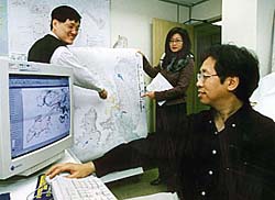 WCIP Christina Leung with two GTR Sergeants in the Force Mapping Centre |
UNDER the Information Systems Wing, the
Force Mapping Centre at Police Headquarters in Caine House has been in operation since
mid-1997 upon the transfer of the Gazetteer Team (GTR Team) from OPS Wing. The centre
is run by four GTR Sergeants, each responsible for the mapping requirements of one to two
police regions as well as for updating the gazetteer statement records, which is essential for
the up-to-the-minute accuracy of the maps produced.
The Force Mapping Centre produces four types of maps for use by police formations and departments Force-wide: regional maps, district boundary maps, divisional boundary maps and beat maps. Customised maps are also produced for special operational purposes, such as the National Day fireworks crowd management, and the relocation from Kai Tak to the new airport at Chep Lap Kok. |
|
The sizes of maps range from A4 to A3, to 3 feet x 4 feet, to as large as 6 feet x 8 feet. The Centre's staff produce the maps on four mapping terminals which employ four colour printers and one plotter. Three terminals are installed with Mapinfo programme software on a Windows 95 platform, while the fourth is installed with Arcview software. Mapinfo is more user friendly but Arcview is more sophisticated in data retrieval and processing and has a better print quality. Arcview can open maps up to territory level, while Mapinfo opens up to district level only. Basic, raw map data is sourced from the Lands Department on the scales of 1:1000 and 1:20000. By next month (April), maps on the scale of 1:5000 will begin to be provided by the Lands Department ˇĐ which is the most suitable scale for police usage because of the amount of information and detail that can be provided on that measure. The raw data from the Lands Department consists of categories such as: buildings with names; roads with names; contour lines; railways (MTR, KCR, LTR); relief maps (that show hills, valleys, etc. by topographical contour lines, shading and other means); hydrology (cliffs, water catchments, reservoirs, rivers, etc.); and utility points (fire hydrants, lamp posts, electric transformers, and so forth). With this new information, the GTR Team can modify the source data to existing maps by adding layers on top of one another to produce amendments to district and divisional boundaries, beat areas and numbers, road and street names, symbols for other operational purposes ˇĐ the list goes on. "The GTR Team consults the Lands Department bi-annually for further updates on the raw data," explained Christina Leung Wai-shan, WCIP CS MSI IS, who oversees the operations of the Force Mapping Centre. "But if there is any new development which has not yet been incorporated in the Lands data, the team members will either draw it on the digitised map by themselves or obtain the latest soft copy from ASD, whichever is more appropriate."Ó Said Sergeant GTR CS ISW Wong Hing-cheong: "When we produced the maps for the new airport, the Lands Department didn't have the digital map data in their system yet, so we had to consult ASD to obtain the maps of the buildings in the area to incorporate the data into our system." He continued: "One of the main challenges of our job is to produce maps using architectural drawings ˇĐ because often that is the only data that exists on a new development. For example, we consulted ASD for the provision of raw data on the Extension of the Convention and Exhibition Centre and the new airport when we had to provide operational maps during the handover and the move to Chek Lap Kok. There were no available maps on the new development in the surrounding areas because all was still in the process of being completed. "It has also been a major challenge for us to supply maps for Traffic Kowloon West for the new Western Lands Reclamation site." Since the inception of the Force Mapping Centre, there has been a significant growth in users' requests from 66 maps in July 1997 to a present monthly average of 200 copies. "Peak" requests for operational maps were recorded before the World Bank Conference (522), Christmas (359), the visit of the US President (222), and the National Day (234). As the GTR Team gets more familiar with the computer mapping programmes, the average time spent for the production of one map has dropped from over two hours in July 1997 to currently an hour. "The way forward," says WCIP Leung, "is to look into the possibility of decentralising Force mapping tools to all the police districts. Because of AICAMS, the districts already have the raw map data in their setups, so if we provide them with the essential map software and training, the districts can create their own customised maps. Until then, if maps are needed, then the regions should call us up and request them."Ó There is another mapping centre at PTU HQ, but that specifically serves PTU's operational needs. | |
Tales from the frontlines . . .
|
"THE sea bed was extremely steep (which
surprised me), and it was full of sharp-edged rocks and piercing cans. Adding to this, it was
virtually impossible to see through the thick and smelly water, so we could only grope our way
towards the woman," recalled Tsuen Wan District PC Ma Wing-hong, who, together with PC
Kwong Wing-fai, saved the life of an unconscious woman after locating then pulling her from
the murky, extremely polluted waters off the Tsuen Wan Ferry Pier on 31 January.
"Given the vast sea surface, it really took some time for us to locate the woman who was apparently unconscious and sinking into the water," said Station Sergeant Chan Kam-hung, who led the two officers to the scene within minutes of receiving the report. |
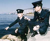 Police Constables Ma and Kwong revisiting the scene of their rescue |
|
But the real test came when the two police constables, after finding the rather obese woman, tried to pull her out of the water onto the sea bank - which was nearly 45 degrees steep and covered with grease and moss. The incident took place in an inlet of stagnant water off the Rambler Channel where there are always large amounts of industrial waste from nearby factories being discharged through sewage pipes. The stench was intolerable and pungent enough to keep people away. "But we hardly noticed the smell when we jumped in," recalled PC Kwong. "All that was on our minds at the time was to save the woman. However, they did gulp down some pretty filthy water during the rescue, which ended with the woman being pulled out of the polluted channel and onto the bank where she was given CPR until an ambulance arrived, which rushed her to the hospital where she recovered. PCs Ma and Kwong were later commended for their bravery by DC Tsuen Wan, Ho Tse-tong. | |